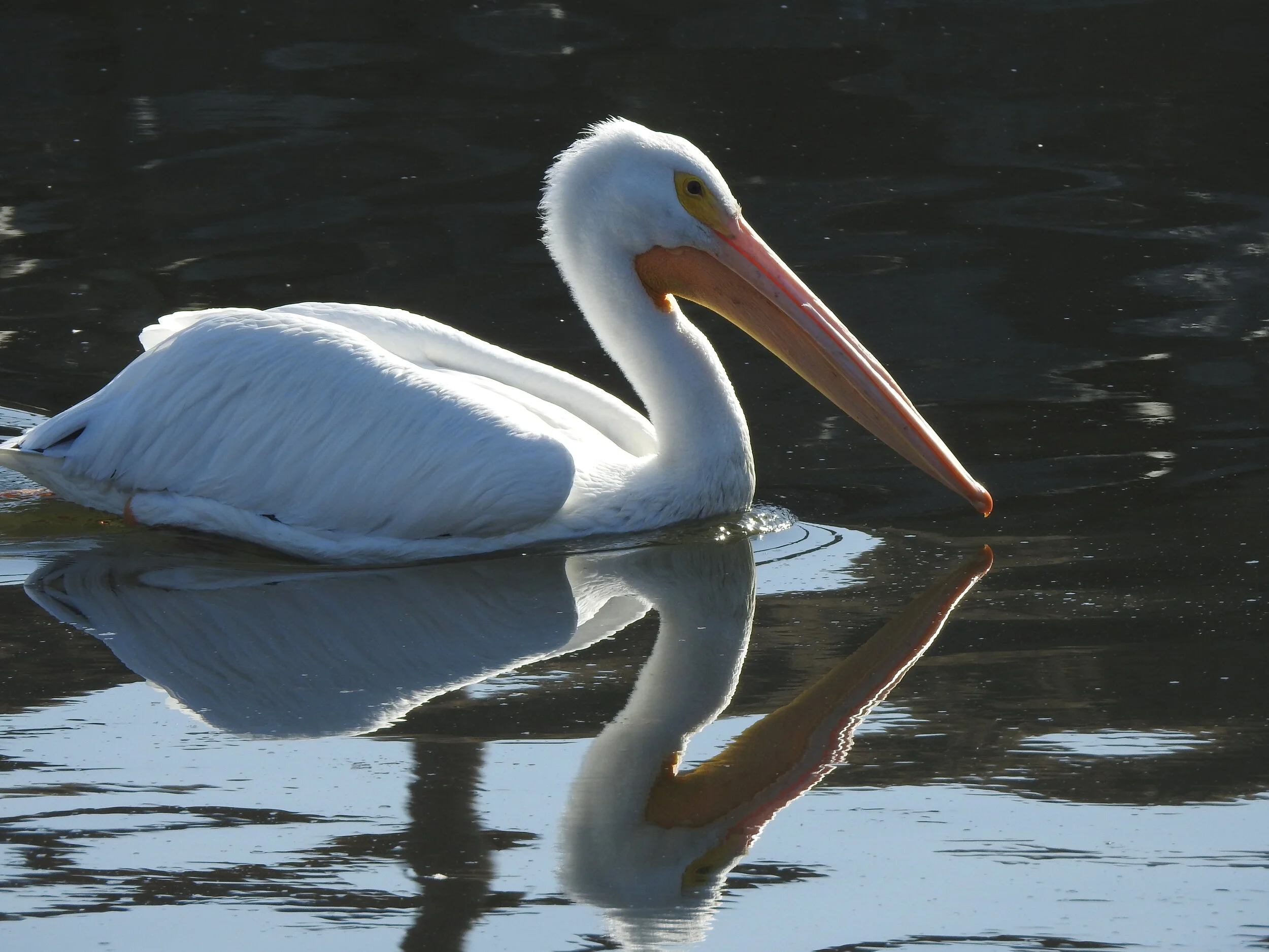
One of the winter visitors recently seen at the Bolsa Chica Wetlands, the magnificent White Pelican. | Photo credit: Margot Griswold
By Cindy Hardin, Director of Outdoor Education | Photos by Margot Griswold and the Author
2020 has been a year that has seen much upending of the world and its citizens. But there is consistency to be found in the natural world, and for me, that is a great source of comfort. Nature does not know that a pandemic is raging around the world, and continues to go about its business, in all its wonder, every single day.
Time spent outdoors can be quite the antidote for the sagging spirit. Southern California abounds in locations that remind us of the beauty of our state, and that there is a larger whole to the world than the niche that is occupied by us humans. What follows is a list of some of my favorite spots to step back, experience the natural world and be inspired rather than discouraged. Each place listed is within a two-hour drive of downtown Los Angeles, with the exception of the final listing. Some are extremely local. And all should be a tonic to malaise!
We will go from north to south. Each site could be done as a day trip, or combined as a multi-day nature vacation once traveling becomes a real possibility again.
All of these excursions can be done safely if current protocols are followed. We all know the drill: explore with members of your own household (or solo!), wear a mask, and keep proper distance when others are encountered. That said, all of these spots, save for Serrano Canyon, have paths wide enough to avoid close contact with strangers.
Every spot listed offers fantastic opportunities to walk, and some are well suited for a two- wheel tour-on a bicycle! A bike and a bike rack allow expanded mobility, and a chance to feel like a kid again. This option will also be described below, when applicable.
Coal Oil Point Reserve- Located at the far north end of the campus of UC Santa Barbara, Coal Oil Point is a nesting site for the threatened Western Snowy Plover. It includes a beautiful beach that is the starting point of the Gaviota Coast, coastal dunes and seasonal ponds and a freshwater slough on the inland side of the dunes. Beautiful any time of year, the Reserve is especially thrilling in Springtime, when the baby Snowy Plovers are running about, learning from their parents how to forage for insects in the kelp wrack. There is a lot with permit parking available, which can be accessed by taking Storke Road/Glen Annie exit off the 101 Freeway. After Storke hits El Colegio continue forward, as at this point it will turn into Slough Road. Signage will direct you to the day parking lot.
Bike option: Exit 101 north at Fairview Road, go right. Make a left at the next stoplight on to Calle Real, and park at the dead end. You will see the entrance to the bike path; bear left at the first crossing. The path follows a creek, and leads along Goleta State Beach onto the campus of UCSB. Ride through the campus to pick up Sabado Tarde, and follow it to its end. Enter the bluff trail, ride along the bluff and terminate at the entrance to Coal Oil Point and the Reserve.

Lots of great information in signage found throughout the Carpinteria Salt Marsh
Carpinteria Salt Marsh- This is almost 300 acres of wetlands that have been restored over the past 20 years or so. There is a walking path around the perimeter of the marsh, with great signage that explains the history and geology of the land, and the species of plants and animals that are found there. Park as closely as possible to the corner of Ash and Sandyland.
Bike Option: After covering the perimeter trail on foot, take your bike south along the beach and enter the trail that runs along the back edge of Carpinteria State Park. This will take you to the Carpinteria Bluffs-more beautiful open space. If your trip is taken in the springtime you can observe the Harbor Seal rookery on the beach, below the bluffs. Adorable seal pups can be seen scooting about, and learning to swim in the shallows.
Carpinteria Bluffs- You can still access the bluffs even if you don’t have a bike! There is a parking lot located at the intersection of Bailard Road and Carpinteria Avenue. Park in the lot and follow the meandering paths through restored Coastal Sage Scrub habitat. Head towards the north end, cross the railroad tracks and look for seals on the beach.
Sycamore Canyon- This is part of Point Mugu State Park, located just north of County Line, and covers both sides of Pacific Coast Highway. Past the campground on the inland side is a fire road that goes all the way up the canyon, terminating in the valley at Satwiwa Park, about 8 miles. The road crosses Sycamore Creek numerous times, and massive Sycamore Trees, stands of native Oak and Willows are found all along the trail. One mile in you will find the trailhead for Serrano Canyon, which follows Serrano Creek. Great place for spring wildflowers, and in past years Red Tail Hawks have nested on a rock ledge that can be seen about two miles in along the creek. If you are feeling ambitious you can continue on the Serrano Creek trail, as it will loop you back to the Fire Road further up the canyon.
Bike Option: The Fire Road is a wide and easy bike ride. Around six miles in the road will start a steep ascent-I lock my bike to the side of the trail at that point, go up the last section of road on foot, and then bear right once I get to Satwiwa. This trail will take you back down along another creek, and you will pop out where you parked your bike!
Malibu Lagoon- Malibu Lagoon is one of those iconic spots along our coast, so famous that it is known far and wide. A controversial restoration was done here several years ago; opinions vary on levels of its success. Nevertheless, it is a great spot to stop if you are working your way down the coast, and lots of birds are to be seen here, including (at times) the Western Snowy Plover. There is also a terrific 3-D model of the Malibu watershed at the start of the trail that leads to the beach. Lagoon, Coastal Sage Scrub and Beach areas make this a great trifecta of native habitat.

The jetty where Ballona Creek meets the sea.
Ballona Creek, Lagoon, Jetty, Wetlands and Freshwater Marsh- Closer to home, we have the last coastal wetland within the city limits of Los Angeles. Public access to the wetlands themselves is quite limited, and currently, due to Covid-19 restrictions, completely off the table. However, there is a fair amount of street parking in Playa del Rey, especially in the morning hours, and lots to see. The Lagoon is a good starting point, and heading north will take you to the Ballona Creek Jetty. Recently there have been loads of Winter Migratory birds present, including Surfbirds, Elegant Terns, Oystercatchers and multiple gull species along the jetty and adjacent beach. If you turn back and head east on the jetty you will be able to peer through the fence and get a peek at Ballona. The Freshwater Marsh, located at the corner of Jefferson and Lincoln, is also full of winter birds. Look for ducks, warbler species and White Crown Sparrows at this spot.
Bike Option: Ballona Creek Bike Path runs along the north side of the creek, all the way to Culver City and the Baldwin Hills. There are multiple entrances to the bike path, and as you get closer to the ocean, you will pass by both Area C and Area A of the Ballona Wetlands. Great birding to be had on the creek along the path, especially west of Centinela during low tide
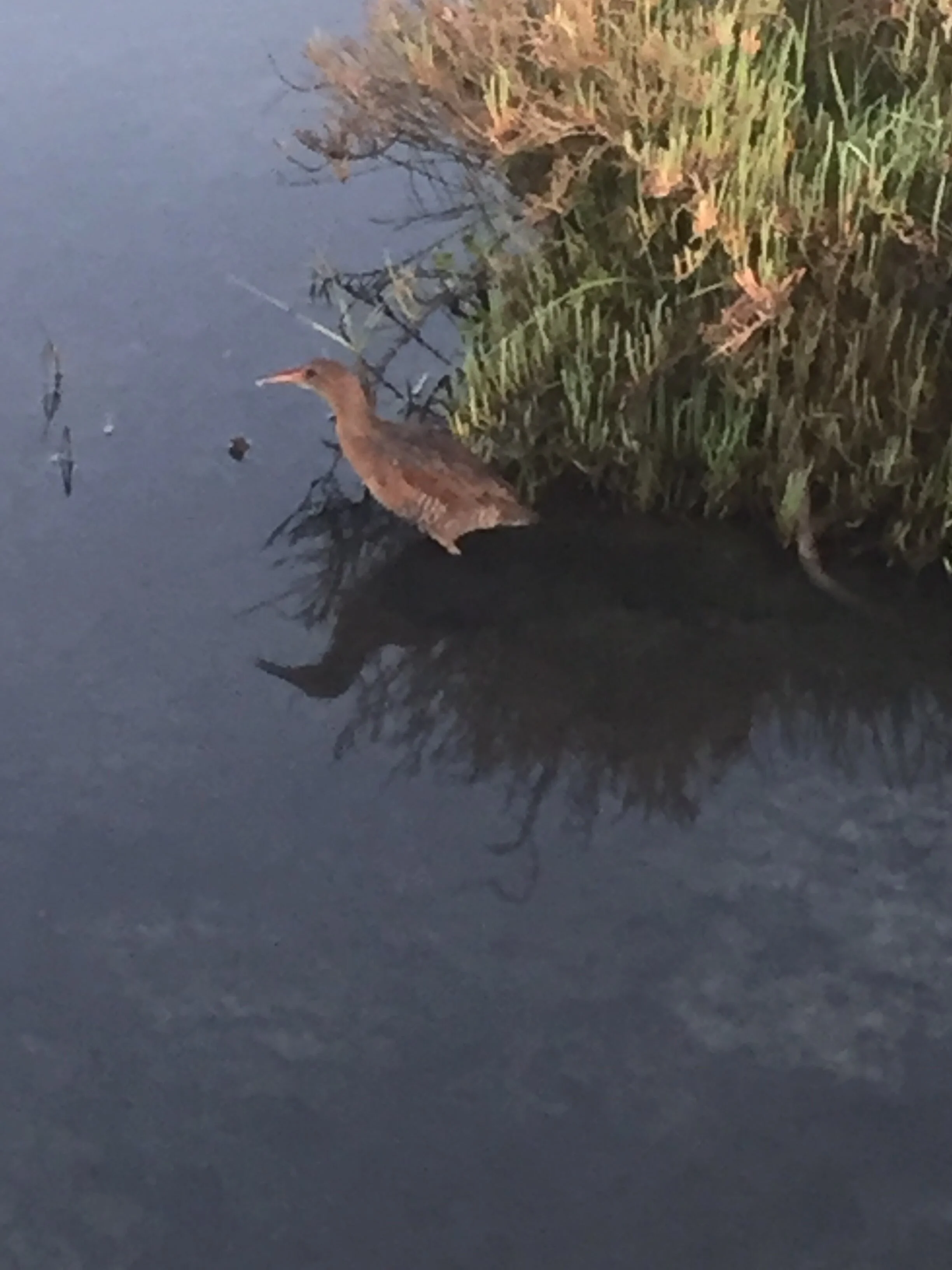
Ridgway’s Rail ( say that three times fast!) at Bolsa Chica.
Bolsa Chica Wetlands and Bolsa Chica State Beach- Our neighbor to the south includes the Bolsa Chica Ecological Reserve, which is twice the size of Ballona and accessible to the public from dawn to dusk. Miles of hiking trails, upland habitat, great views from the upper mesa and birds, birds, birds! Make sure to get over to the “pocket wetland”, just south of and below the mesa, where a gorgeous flock of White Pelicans has been spending the winter. And keep an eye out for the resident Osprey, who loves to use the snag above the pocket wetland to roost and shred its fish breakfast. Parking is available off Warner Avenue and PCH, and also on the inland side of PCH, opposite the main entrance to Bolsa Chica State Beach.
Bike Option: Huntington Beach is the only city in Orange County that did not ever allow development along the ocean side of Pacific Coast Highway, save for one outlier condo complex next to the pier. This means that there is 11 miles of off-road designated bike path along the sand. There are areas of beautifully restored dune habitats in the Bolsa Chica State Beach section of the path, and ocean views, which on clear days includes stunning vistas of Catalina, all along the path. Dolphins are a common sight and lots of birds are always present! Least Terns breed in the summer months in the wetlands across the highway, and also just before the Santa Ana River at the south end of Huntington-their sounds are cacophonous when they are present!
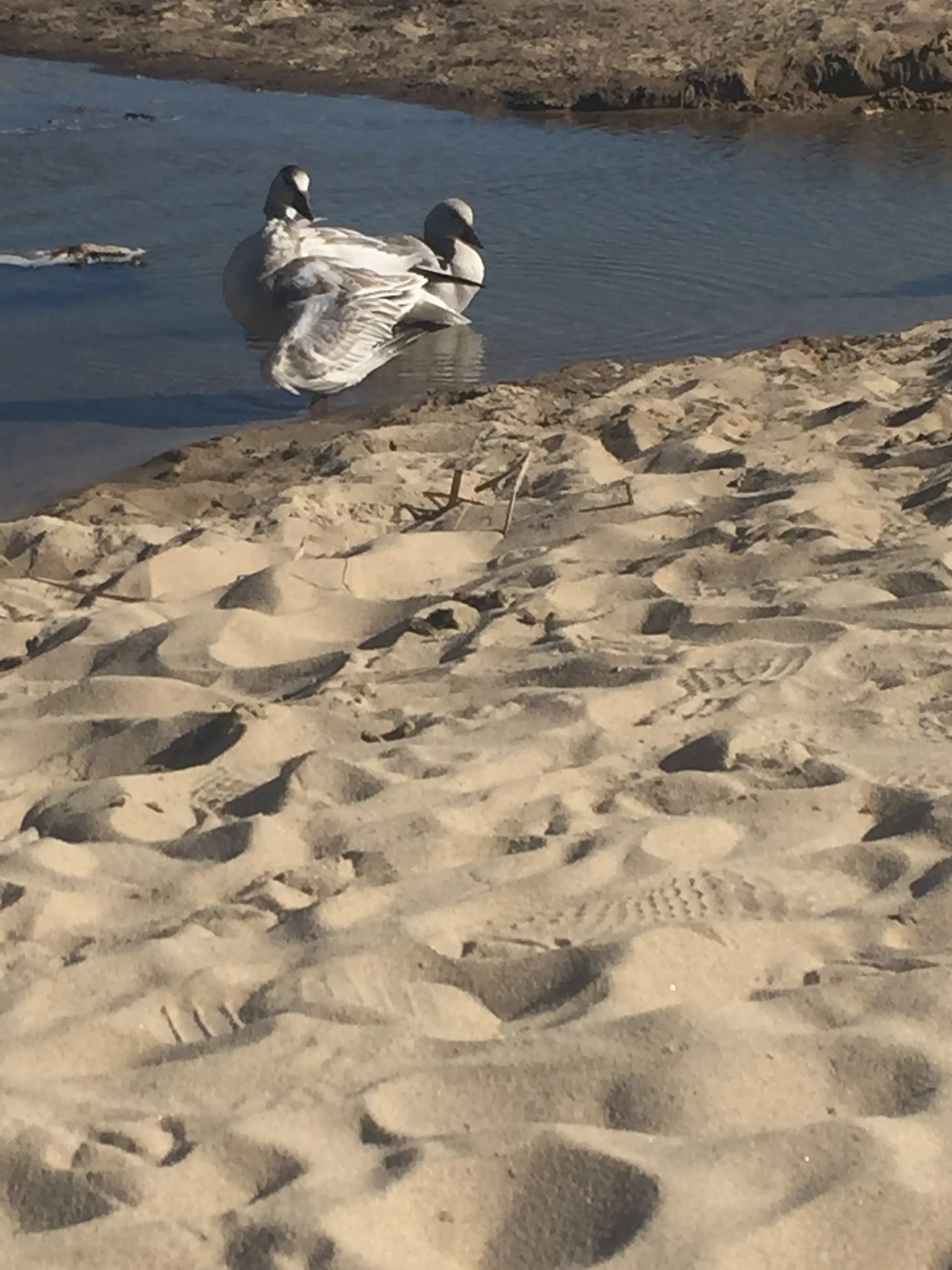
A pair of Snow Geese on a re- fueling stop at Crystal Cove State Park.
Crystal Cove State Park- Lots of options here at this coastal gem, which stretches three and half miles between Newport Beach and Laguna Beach. There are walking paths that wander through the bluffs that have been beautifully restored with Coastal Sage Scrub habitat, and the beach offers wide stretches of sand and great tidepool viewing at low tide. At the south end you will find El Moro Canyon, which provides access to hiking trails up this coastal canyon. You can hike straight up the canyon, or bear right a mile up from the parking lot and pick up the El Moro Ridge loop. A four-mile loop hike will take you high up the ridge, with stunning coastal views and loads of native habitat.
Bike option: The hiking paths on the bluff top can also be used as a bike path, although I prefer to take it slow on this trail and watch for wildflowers and great birds, like the California Thrasher.
La Jolla Cove- Another great stop as you work your way down the coast to our final destination. The highlight here can be found underwater! That’s right-amidst the bustle of La Jolla Village is a protected cove that abounds with sea life. Lots of parking all around the adjacent bluff top park, and stairways down to the cove provide easy access. Our state ocean fish, the Garibaldi, is present looking like giant goldfish in this natural aquarium, and juvenile sea lions frolic and show off their water prowess. In summer time the water is warm enough that all that is required is snorkel and fins; winter requires a wetsuit. And even if you don’t get in the water, the coastal views are excellent, and sea lions can be seen from the bluffs above.
Imperial Beach, Tijuana River National Estuarine Research Reserve- our final stop, and the last coastal town before the United States turns into Mexico. Imperial Beach is a throwback to the coastal towns of my youth, and still has the atmosphere of a real surf town, complete with many delicious taco options. The Reserve is located at the far south end of town, and you are able to walk along the beach to the mouth of the Tijuana River. Plenty of inland trails throughout the Reserve as well, and a great Visitors’ Center that, although currently closed due to pandemic restrictions, provides an overview of the Reserve and lots of information about this very special place.
Bike option: At the north end of Imperial Beach there is an off-road bike path that runs along the coastal strand all the way to Coronado Island. Lots of wetland habitat on the inland side, and beautiful beaches on the coastal side. There is also a side spur that will take you inland to the Otay River, which is also a Reserve. Pack a lunch so you can take a sustenance break-if you make it all the way to Coronado and back you will cover about 18 miles!
NOTE: The directions that I am providing are quite general. However, with the magic of Google you can find more information and detailed trail maps of all of the above spots. Also, many mentioned are part of our wonderful State Park System, which means paid entry fees. I highly recommend the purchase of an Annual Pass, which costs $200.00. This will cover your parking fees at every State Park in California, and help to support our Parks, as every dollar of your park pass purchase goes directly to the parks. I usually make back what I spend on my pass within seven months of purchase. Bonus: if you buy your pass at the beginning of the month, it will be good for thirteen months, not twelve!

The bluffs of Crystal Cove State Park with spring wildflowers.